
Sonardyne USBL Systems Set Sail on Glacier Climate Mission
Sonardyne USBL Systems Set Sail on Glacier Climate Mission
A climate science mission using marine robots, in formation and closer to glaciers than they’ve been before, sets sail this summer with support from Sonardyne underwater positioning technology.
The GIANT project, which stands for GIANT stands for "Greenland Ice sheet to AtlaNtic Tipping points from ice loss," is led by British Antarctic Survey (BAS) and is investigating how the warming ocean is making Greenland’s tidewater glaciers melt and what this means for our global climate.
To do this, the UK’s polar research ship RRS Sir David Attenborough will send a fleet of autonomous vehicles (aerial, surface and subsea) as a connected observing system, into one of the world’s most extreme environments to get the most comprehensive data possible.
Sonardyne’s Ranger 2 Ultra-Short BaseLine (USBL) positioning system onboard the RRS Sir David Attenborough and a Mini-Ranger 2 USBL system on the daughter craft Erebus will be used to track and control formation operation of the mission’s underwater vehicles as they map the glacier’s underwater face.
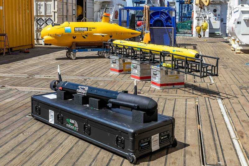
The underwater vehicles being used include the UK National Oceanography Centre’s AutoSub Long Range (ALR, AKA Boaty McBoatface), a Teledyne Gavia and ecoSUB Robotics autonomous underwater vehicles (AUVs).
The GIANT project involves 15 collaborating institutions, five technology partners and is backed by the UK’s Advanced Research and Invention Agency (ARIA) as part of the Forecasting Tipping Points program.
The GIANT mission will run from July into August this year at tidewater glaciers near Kangerlussuaq Fjord with a goal to map, measure, and monitor everything from ocean water temperature to glacier movement using autonomous vehicles.
Alongside the underwater vehicles, there will be embedded robotic sensors tracking melting below the surface, a DriX uncrewed surface vessel at the surface and aerial drones surveying the ice from above.
Related Stories
 Technology
Can Strong LEAP Momentum Boost ASE Technology's Long
58 minutes ago
 Technology
REG - Bytes Technology Grp Barclays PLC
58 minutes ago
 Technology
ContractorHUB Named a 2026 Venture Atlanta Showcase Company Among the Top Startups in the Southeast
1 hour ago
 Technology
Hoenfong adopts Välinge Innovation herringbone technology
1 hour ago
 Technology
Defense tech Mach Industries doubles valuation to $3.7B in 3 months
2 hours ago
 Technology
SAFENet Expands: New members join European router and network technology alliance / Five companies from four countries join the alliance for Europe's technological sovereignty
2 hours ago
 Technology
PilotAL expands statewide, pairing Alabama companies with growth
3 hours ago
 Technology
Sonatel joins digital stakeholders to examine Africa’s geostrategic technology future
4 hours ago